Expansions
On closer examination, Scandinavian expansion started well before the Viking Age and did not always fit the raiding pattern. There was ongoing
settlement of the islands north and east of Scotland - some of them previously used as hermitages by Irish monks - in particular by those who resented
Xianization and increasing royal pride, the same issues that led to the settlement of Iceland. As early as 650, Norsemen (primarily from Norway) settled
in the Orkney Islands, the Shetland Islands to the northeast of them, the Faroe Islands still further to the north and west, and the outer and inner
Hebrides west of Scotland. Many settlers moved from one set of islands to another, and some later came from mainland Scotland.
Similarly, the Germans and the Slavs to the east of them were always in an uneasy relationship. The missionaries among the German peoples had stopped
at the Elbe. But as mentioned above, the Carolingians made vassals of some of the Slavic peoples, notably the Obotrites and Wends along the coast of the
Baltic; their lands became "marches," meaning a subject borderland. And in 831-4 Charlemagne's grandson Pepin I established a bishopric in Hamburg, near
the mouth of the river, and a century later, in 946-49, Emperor Otto I campaigned seriously to convert and subdue the West Slavs. This led to the
establishment (in 962-99) of Poland as a Catholic bulwark amid the still pagan Slavic lands. But the Wends (a term that came to be used for all the West
Slavs) remained pagan, and threw out missionaries in 1018 and 1066 (Jones and Pennick 167). In addition to the desire to subjugate the Slavs and convert
them to Xianity, there was constant need for land for the Germans and a corresponding desire on the part of the Frankish rulers and then the Holy Roman
Emperors to populate new areas with loyal subjects and thus extend the Empire. These areas to the east are referred to as Germania Slavica; in this first
phase of expansion, the eastward boundary was the Oder, with the area between there and Poland remaining Wendish.

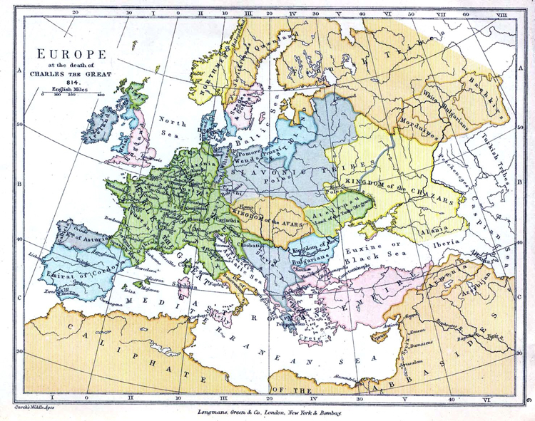
Map created by Charles Colbeck, corrected by AlexD, Wikimedia Commons
In this map of Europe at the end of Charlemagne's realm, the eastern boundary of the green area largely follows the Elbe, and the Obotrites, Wiltzes,
and Wends can be seen just east of it, the first two within the green line indicating subject status. The western edge of the territory indicated for the
Wends is the Oder.
In the opposite direction, there were also a few Anglo-Saxon settlers in Ireland. The earliest were devout Celtic Xians. In particular following the
Synod of Whitby in 664, at which King Oswiu ruled that the church in Northumbria would follow Papal doctrine and not Irish Celtic, St.Colmán, then bishop of
Lindisfarne, left his bishopric and with some Irishmen and 30 Northumbrians went first to Iona and then from there to Inishbofin off the west coast of
Connacht, where he founded a monastery. But the Anglo-Saxons and Irish could not get along, so for the former Colmán founded Maigh Eo, which later gave its
name to County Mayo. In later times, King Alfred reputedly sent English settlers over to Ireland.
[1. Europe under Charlemange map image from http://en.wikipedia.org/wiki/File:Europe_814.jpg]
